| Home | Email Us | Find It | What's New | Back | Next | ||
| VIEWER MESSAGES | ||
|
| MISCELLANEOUS | ||||
|
||||
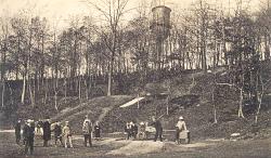 Click image to enlarge
|
The Early Years
The first settlers came to this part of Long Island in the mid-1600's. They were Dutch, and they gave the name "Whiteput" (meaning "hollow creek") to the area around northern Kew Gardens and Forest Hills. When the English took over the Dutch Colony in New York, they changed the name to "Whitepot". Whitepot included the northernmost parts of today's Kew Gardens. The part nearest Forest Hills came to be known as Hopedale. The part nearer Jamaica became Maple Hill Park. Eventually, both were absorbed into Kew Gardens. Whitepot was part of the Township of Newtown which stretched across Central Queens from Jamaica to Long Island City. During the American Revolution, British soldiers under the command of Gen. William Howe made their encampment at the site of today's Union Turnpike and Queens Boulevard.
Sources:
- 1907 photograph from the Lucy Ballenas Collection courtesy of Carl Ballenas
References:
- Barry Lewis, Kew Gardens: Urban Village in the Big City, p. 6 (Kew Gardens Council for Recreation and the Arts 1999)
- William Krooss, A Peek at Richmond Hill Through the Keyhole of Time, p. 5 (1994)
- Vincent F. Seyfried & William Asadorian, Old Queens, N.Y. in Early Photographs, p. v (Dover Publ. 1991)