| Home | Email Us | Find It | What's New | Back | Next | ||
| VIEWER MESSAGES | ||
|
| MISCELLANEOUS | ||||
|
||||
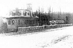 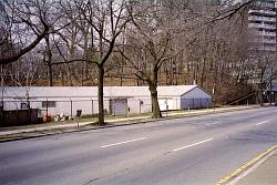 Pictures dated c. 1905 and 2004
Click images to enlarge |
Dying to Get In
Maple Grove Cemetery opened in 1875 as an alternative to the overcrowded Prospect Cemetery in Jamaica (opened 1668). Located on one of the highest elevations in Queens, Maple Grove was said to have beautiful views of Long Island Sound and the Atlantic Ocean - views which have since been obscured by the area's commercial and residential development. This is the Queens Boulevard entrance. You are looking toward 83rd Avenue. Before there was a Kew Gardens, this area was part of the Jamaica Township. The "lodge" is now gone.
Source:
- C. 1905 picture courtesy of the Queens Borough Public Library, Long Island Division, Illustrations Collection - Kew Gardens
Reference:
- Barry Lewis, Kew Gardens: Urban Village in the Big City, p. 13 (Kew Gardens Council for Recreation and the Arts 1999)