| Home | Email Us | Find It | What's New | Back | Next | ||
| VIEWER MESSAGES | ||
|
| MISCELLANEOUS | ||||
|
||||
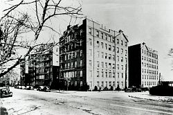 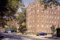 Pictures dated 1940 and 2004
Click images to enlarge |
Kew Gardens Road
Until the mid-19th Century, the Kew Gardens, Briarwood sections of Queens Boulevard were nothing but marshland and an estuary (inlet). The Boulevard itself did not exist. In those days, only one road connected Jamaica Township to our east with the Town of Elmhurst (then called Newtown) to our west. That road was called Whitepot Road - later, Newtown Road - and it ran through a hilly area just south of the marsh. Today, that hilly area is Kew Gardens, and the road is Kew Gardens Road.
Source:
- 1940 picture courtesy of the Queens Borough Public Library, Long Island Division, Illustrations Collection - Kew Gardens