| Home | About Us | Email Us | Find It | What's New | Back | Next | |
| VIEWER MESSAGES | ||
|
| MISCELLANEOUS | ||||
|
||||
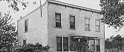 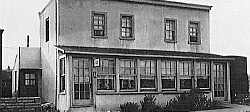  Pictures dated c. 1930 and 2002
Click images to enlarge |
Hayestown
Kew Gardens was not just a shining city on a hill. True, the area west of Lefferts was the site of the Richmond Hill Golf Club, and later, the exclusive housing development called Kew. But east of Lefferts (along today's Austin Street) was a different story. In the 1890's and early 1900's, it was home to about 100 black people who lived in small huts, many with thatched roofs. Some of those shacks survived to the 1930's. In the 1960's, it was still considered a rough neighborhood.
Sources:
- Undated Manuscript by William Krooss, p. 11
- 1930 pictures courtesy of the Queens Borough Public Library, Long Island Division, Illustrations Collection - Kew Gardens