| Home | Email Us | Find It | What's New | Back | Next | ||
| VIEWER MESSAGES | ||
|
| MISCELLANEOUS | ||||
|
||||
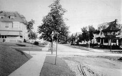 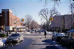 Pictures dated c. 1920 and 2003
Click images to enlarge |
The Two Synagogues
These pictures are of Abingdon Road looking east toward Lefferts Boulevard. When the black and white picture was taken, there were dirt roads, and private homes occupied the far corners. Today the homes, like the dirt roads, are gone, and in their place stand two synagogues. Adath Yeshurun (on the left) was built in 1948, and Shaare Tova (on the right) was built c. 1980.