| Home | Email Us | Find It | What's New | Back | Next | ||
| VIEWER MESSAGES | ||
|
| MISCELLANEOUS | ||||
|
||||
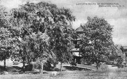 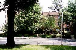 Pictures dated c. 1914 and 2003
Click images to enlarge |
North of 84th Avenue
"[By] 1905 the community [of Richmond Hill] had some 15,000 homes, most of them shingle-style frame Victorians, and was quickly pushing its way up the slope from Jamaica Avenue (the former plank road) toward the newly opened Forest Park and the Richmond Hill Golf Club in neighboring Maple Grove [today's Kew Gardens]. By 1909, the golf club was being hemmed in by the 'cottages' in which Richmond Hill's wealthier citizens preferred to dwell."
Sources:
- Quote from: Winkleman, "Inside Kew Gardens," Metropolis Magazine (October 1982) (Bracketed text is mine)
- Circa 1914 picture from the Lucy Ballenas Collection courtesy of Carl Ballenas